We would like to bring to your attention a selection of recent publications by our CRANE partners from the Carleton University, Durham University, and from our core members at the University of Toronto.
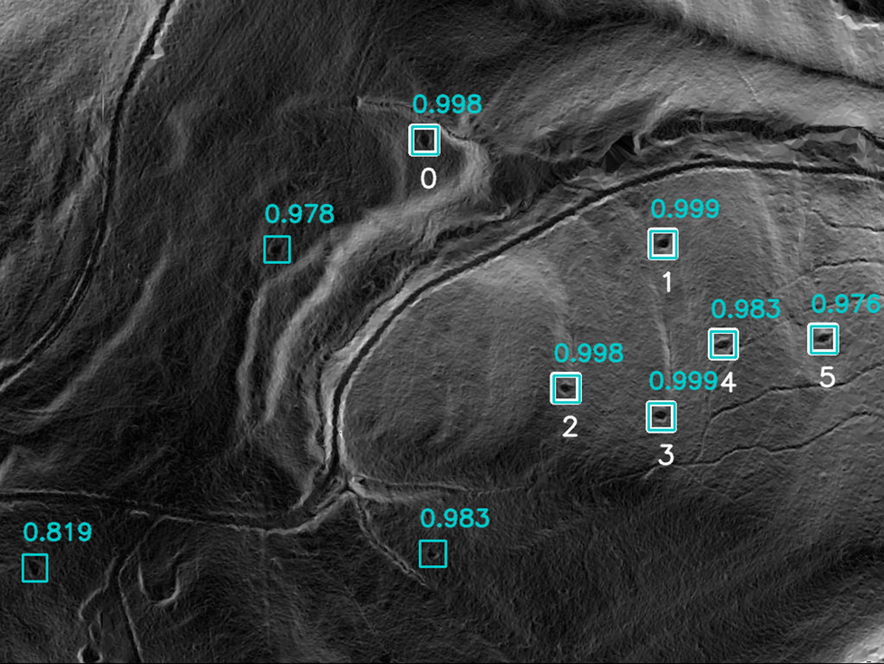
Carter, B., Blackadar, J., & Conner, W. (2021). When Computers Dream of Charcoal: Using Deep Learning, Open Tools, and Open Data to Identify Relict Charcoal Hearths in and around State Game Lands in Pennsylvania. Advances in Archaeological Practice, 1-15.
Abstract
This research employs machine learning (Mask Region-Based Convolutional Neural Networks [Mask R-CNN]) and cluster analysis (Density-based spatial clustering of applications with noise [DBSCAN]) to identify more than 20,000 relict charcoal hearths (RCHs) organized in large “fields” within and around State Game Lands (SGLs) in Pennsylvania. This research has two important threads that we hope will advance the archaeological study of landscapes. The first is the significant historical impact of charcoal production, a poorly understood industry of the late eighteenth to early twentieth century, on the historic and present landscape of the United States. Although this research focuses on charcoal production in Pennsylvania, it has broad application for both identifying and contextualizing historical charcoal production throughout the world and for better understanding modern charcoal production. The second thread is the use of open data, open source, and open access tools to conduct this analysis, as well as the open publication of the resultant data. Not only does this research demonstrate the significance of open access tools and data but the open publication of our code as well as our data allow others to replicate our work, to tweak our code and protocols for their own work, and reuse our results.

______________________________________________________________________________
Graham, S., and Simons, J., 2021, Listening to Dura Europos: An Experiment in Archaeological Image Sonification. Internet Archaeology 56.
Excerpt from the Introduction
Jennifer Baird writes, of the Yale University–French Academy Expedition to Dura Europos in 1928-1937 and the way the expedition composed photographs for record keeping and publication, ‘What might an archaeology of Dura have looked like if objects had been photographed as assemblages from single contexts rather than in typological or material-based groups?’ (2011, 442).
We ask instead, what might the archaeology of Dura Europos sound like?
What can we hear, if we extend our senses through digital prostheses to extend our ability to sense the world? In this article we present an experiment in sonifying the archaeological imagery analysed by Baird (2011) as a way of enhancing our engagement with these archival photographs.
______________________________________________________________________________
Morrison, K., E. Hammer, O. Boles, M. Madella, N. Whitehouse, M.-J. Gaillard, J. Bates, M. Vander Linden, S. Merlo, A. Yao, L. Popova, A.C., F. Antolin, A. Bauer, S. Biagetti, R. Bishop, P. Buckland, P. Cruz, D. Dreslerova, G. Dusseldorp, E. Ellis, D. Filipovic, T. Foster, M. Hannaford, S. Harrison, M. Hazarika, H. Herold, J. Hilpert, J. Kaplan, A. Kay, K.K. Goldewijk, J. Kolar, E. Kyazike, J. Laabs, C. Lancelotti, P. Lane, D. Lawrence, K. Lewis, U. Lombardo, G. Lucarini, M. Arroyo-Kalin, R. Marchant, M. McClatchie, M. McLeester, S. Mooney, M. Moskal-del Hoyo, V. Navarrete, E. Ndiema, M. Nowak, W. Out, C. Petrie, L. Phelps, Z. Pinke, T. Russell, A. Sluyter, A. Styring, S. Veerasamy, L. Welton, and M. Zanon. (2021) “Mapping past human land use using archaeological data: a new classification for global land use synthesis and data harmonization”. PLoS ONE 16(4): e0246662.
Abstract
In the 12,000 years preceding the Industrial Revolution, human activities led to significant changes in land cover, plant and animal distributions, surface hydrology, and biochemical cycles. Earth system models suggest that this anthropogenic land cover change influenced regional and global climate. However, the representation of past land use in earth system models is currently oversimplified. As a result, there are large uncertainties in the current understanding of the past and current state of the earth system. In order to improve representation of the variety and scale of impacts that past land use had on the earth system, a global effort is underway to aggregate and synthesize archaeological and historical evidence of land use systems. Here we present a simple, hierarchical classification of land use systems designed to be used with archaeological and historical data at a global scale and a schema of codes that identify land use practices common to a range of systems, both implemented in a geospatial database. The classification scheme and database resulted from an extensive process of consultation with researchers worldwide. Our scheme is designed to deliver consistent, empirically robust data for the improvement of land use models, while simultaneously allowing for a comparative, detailed mapping of land use relevant to the needs of historical scholars. To illustrate the benefits of the classification scheme and methods for mapping historical land use, we apply it to Mesopotamia and Arabia at 6 kya (c. 4000 BCE). The scheme will be used to describe land use by the Past Global Changes (PAGES) LandCover6k working group, an international project comprised of archaeologists, historians, geographers, paleoecologists, and modelers. Beyond this, the scheme has a wide utility for creating a common language between research and policy communities, linking archaeologists with climate modelers, biodiversity conservation workers and initiatives.
______________________________________________________________________________
Gaastra, J., L. Welton, M. de Gruchy, and D. Lawrence (2021). “Landscapes, Climate and Choice: Examining Patterns in Animal Provisioning Across the Near East, c. 13,000-0 BCE”. Quaternary International 595: 54-87.
Abstract
Understanding the organisation of food production is vital for understanding ancient societies. Multiple factors may influence decision making, including the local environmental capacity of a given area and individual and cultural preferences. This study compares zooarchaeological data from sites across the length and breadth of the Holocene Near East with modelled patterns of land use. The goal is to determine how far variation in the capacities of local landscapes impacted the choices made in animal production. Our approach allows us to investigate trends through time as well as between different regions of the Near East. The spatial and temporal scales employed also mean we can investigate the relationship between food production and climate trends. We find substantial patterning in the choices made in animal production, reflecting complex and regionally diverse production approaches. We demonstrate a prioritisation of individual and societal preferences to produce specific animals which is rarely impacted by either short or long term changes in aridity. We also find that the emergence of urban sites has a major impact on provisioning structures, and argue that the resulting organisational forms may have resulted in urban sustainability at the expense or rural sites.
