CRANE

Inside CRANE

Powered by Genesis

New Publication

Rare drought coincided with Hittite Empire collapse

Reposted from Cornell Chronicle, 8 February, 2023.

The researchers scrutinized tree ring samples recovered from the Midas Mound Tumulus at Gordion, a human-made 53-meter-tall structure located west of Ankara, Turkey.  (John Marston/Provided)

The group’s paper, “Severe Multi-Year Drought Coincident with Hittite Collapse Around 1198-1196 BC,” published Feb. 8 in Nature.

The Hittite Empire emerged around 1650 BC in semi-arid central Anatolia, a region that includes much of modern Turkey. For the next five centuries, the Hittites were one of the major powers of the ancient world, alongside the Assyrian, Babylonian and Egyptian empires, and they remained remarkably resilient amid the various upheavals – social, political, economic and environmental – of the age. But around 1200 BC, the capital at Hattusa was abandoned, and the Hittite Empire was no more.

To find an explanation for the empire’s much-debated collapse, Sturt Manning, Distinguished Professor of Arts and Sciences in Classical Archaeology and the paper’s lead author, teamed up with Jed Sparks, professor of ecology and evolutionary biology, both in the College of Arts and Sciences.

The growth rings inside a juniper tree, combined with isotope records, helped researchers pinpoint a likely culprit for the collapse of the Hittite Empire: three straight years of severe drought, approximately 1198–96 BC, in an already dry period. (Cornell Tree-Ring Laboratory/Provided)

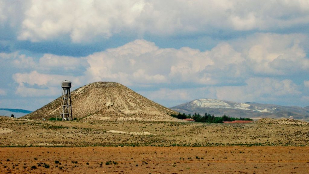
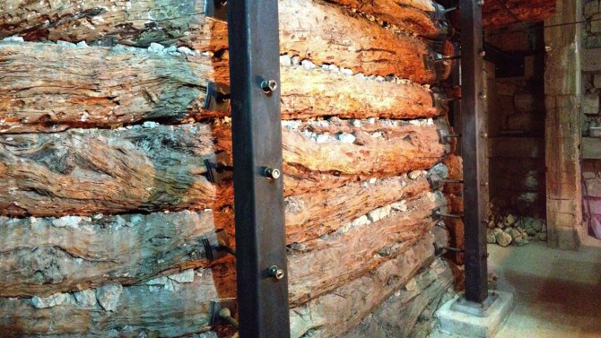
Manning and Sparks combined the capabilities of their respective labs, the Cornell Tree-Ring Laboratory and the Cornell Stable Isotope Laboratory (COIL), to scrutinize samples from the Midas Mound Tumulus at Gordion, a human-made 53-meter-tall structure located west of Ankara, Turkey. The mound contains a wooden structure believed to be a burial chamber for a relative of King Midas, possibly his father. But equally important are the juniper trees – which grow slowly and live for centuries, even a millennium – that were used to build the structure and contain a hidden paleoclimatic record of the region.

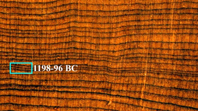
The researchers looked at the patterns of tree-ring growth, with unusually narrow rings likely indicating dry conditions, in conjunction with changes in the ratio of carbon-12 to carbon-13 recorded in the rings, which indicate the tree’s response to the availability of moisture.

“Stable isotopes are one of our strongest ways of looking into the past and asking questions about the physiological state of that plant 1,000, 2,000, 3,000 years ago,” Sparks said. “These are very, very small quantities of wood: Some of the tree-rings are only fractions of a millimeter wide. You’re basically trying to measure a neutron and a very small amount of carbon in wood. So it becomes technologically very difficult to do. Sturt and I worked for three or four years to make this work really well.”

Their analysis finds a general shift to drier conditions from the later 13th into the 12th century BC, and they peg a dramatic continuous period of severe dryness to approximately 1198–96 BC, plus or minus three years, which matches the timeline of the Hittite’s disappearance.

“We have two complementary sets of evidence,” Manning said. “The tree-ring widths indicate something really unusual is going on, and because it’s very narrow rings, that means the tree is struggling to stay alive. In a semi-arid environment, the only plausible reason that’s happening is because there’s little water, therefore it’s a drought, and this one is particularly serious for three consecutive years. Critically, the stable isotope evidence extracted from the tree-rings confirms this hypothesis, and we can establish a consistent pattern despite this all being over 3,150 years ago.”

One year of drought in a semi-arid environment would be manageable, with subsistence farmers typically having enough stored provisions to get them through the year. By the second year, a crisis would develop and “the whole system would start to break down,” said Manning, who cited the Ottoman Empire’s near collapse in the early 17th century from two consecutive years of dramatic drought.

At three consecutive years of drought, hundreds of thousands of people, including the enormous Hittite army, would face famine, even starvation. The tax base would crumble, as would the government. Survivors would be forced to migrate, an early example of the inequality of climate change.

“Probably some of what goes wrong at the end of the Bronze Age is a version of exactly what we see going wrong in the modern world, which is that groups of people are trying to move somewhere else, because they aren’t in a place that’s regarded as suitable or good,” Manning said. “They can see or hear that there are better opportunities elsewhere.”

A wooden structure inside the Midas Mound Tumulus contains a hidden paleoclimatic record of the region. (John Marston/Provided)

Severe climate events may not have been the sole reason for the Hittite Empire’s collapse, the researchers noted, and not all of the ancient Near East suffered crises at the time. But this particular stretch of drought may have been a tipping point, at least for the Hittites.

“Situations where you get prolonged, really extreme events like this for two or three years are the ones that can undo even well-organized, resilient societies,” Manning said.  

That finding has particular relevance today, when global populations are reckoning with catastrophic climate change and a warming planet.

“We may be approaching our own breaking point,” Manning said. “We have a range of things we can cope with, but as we are stretched too far beyond that, we’ll hit a point where our adaptative capacities are no longer matched against what we’re facing.”

Co-authors include former research associate Brita Lorentzen, ’06, Ph.D. ’15, now with the University of Georgia, and Cindy Kocik, M.A. ’14, now with the University of Wisconsin, La Crosse. The wood samples were analyzed for carbon isotope ratio by Kimberlee Sparks, a research support specialist with COIL.

The research was partially supported by the Computational Research on the Ancient Near East project, which is funded by the Social Sciences and Humanities Research Council of Canada and based at the University of Toronto.

CRANE Fieldwork in Northern Iraq:

The Tepe Gawra Lower Town Survey

Also this past October, a second team from NMC led by Dr. Khaled Abu Jayyab (CRANE postdoctoral researcher), carried out survey work around the site of Tepe Gawra. Tepe Gawra is located roughly 20 km to the northeast of Mosul and just to the south of the town of Fadiliyah in the Ninawa Governate, Northeastern Iraq (Fig.1).


Figure 1: Location of Mosul and Tepe Gawra and other contemporary sites.

Tepe Gawra (Fig.2) has long been seen as an essential site for late prehistoric and early historic periods, not only in Iraq but for the entirety of Northern Mesopotamia. Despite its significance, work at Tepe Gawra hasn’t been carried out at the site since the 1930s. The early excavations, conducted at the site by Speiser and the University of Pennsylvania (Speiser 1927, 1935; Tobler 1950) revealed a long occupational sequence dating from the Halaf period to the mid-second millennium BC. The sequence has very few short-lived gaps in occupation and as such has become a chronological anchor for the region, especially for late prehistory (Halaf, Ubaid, and Late Chalcolithic). Analytical work carried out by Abu al-Soof (1974), and more recently Rothman (2002), has expanded our understanding of the Northern Uruk period and has been key to developing the modern Late Chalcolithic (LC1-LC5; 4600-3100 BC) chronological scheme (Rothman ed. 2001; Schwartz 2001).

Figure 2: Drone photo of the site of Tepe Gawra from the north.

Despite its small size (roughly 2-3 ha. at its base extent), Tepe Gawra has been the hallmark site for the development of complexity during the Ubaid and Late Chalcolithic periods in the ancient Near East. Excavations at the site revealed a local development of a sophisticated infrastructure manifest in the construction of temples, monumental architecture, and elaborate administrative technologies. Throughout its occupation, the site shows involvement in far-flung networks connecting it with Highland Anatolia and the Zagros mountains, with connections as far afield as Afghanistan. These connections were seen in the high concentration of objects made of exotic materials such as obsidian, lapis lazuli, carnelian, copper, gold, and silver (Rothman 2002: 8), in addition to the presence of imported utilitarian and luxury ceramics (Abu Jayyab 2019, 2022; Rothman and Blackman 2003). The households at Tepe Gawra were also shown to be involved in multiple craft activities such as woodwork, textile production, elaborate administration, stone tool manufacture, and the production of high-end ceramic wares (see Rothman 2002; Rothman and Blackman 2003).

The main mound of the site has furnished evidence of highly specialized activities (administration, exchange, and craft production) with very little evidence of agricultural implements and farming. This phenomenon is unique as this degree of specialization was only attested at larger contemporary sites that combined specialized activities with extensive farming practices (e.g. Tell Brak reaches over 100 ha during this period). This situation would have necessitated that the inhabitants of Tepe Gawra rely on an external source for food. Rothman suggested that a functional segregation between sites existed in the piedmont or the foothills during this time (Rothman 2002: 5). He saw that the site of Tepe Gawra was a ‘center’ at the top of a specialized hierarchical network. Within this network Gawra served as an administrative, religious, and craft hub (Rothman 2002: 5-6). In support of the notion of a center, Frangipane argues that the landscape played a role in limiting urbanism in the piedmont around Tepe Gawra where the terrain may have restricted the expansion of agriculture beyond its natural limit preventing the region from producing enough agricultural surpluses to support a large conglomeration (Frangipane 2009: 135).

There is no doubt as to the significance of Tepe Gawra within the region but was the site truly dependent on a large regional network for subsistence? That is, was the site serving a special function that excluded it from food production? There remains a debate as to whether or not there was a lower Chalcolithic period town around Tepe Gawra. Algaze notes (1993: 71-72) – based on personal communication with Gibson – that the mound was surrounded by a lower town. If this was true then the high mound would have simply been the acropolis of a larger town that still remains to be systematically explored. Rothman did not reject the idea of the presence of a lower town, however, he remained skeptical with the absence of empirical data (Rothman 2002: 19).

With the permission of the SBAH office in Mosul, Members of the Shamash Gate team Drs. Timothy Harrison, Khaled Abu Jayyab, and Stephen Batiuk had the chance to visit the site on October 1st 2021. The question heading to the site was whether or not the site had a lower town. Immediately upon arrival, a dense scatter of sherds was found to cover the surrounding (lower town) area of the site, and from what could be observed, most of the sherds seemed to date to the Late Chalcolithic period. This realization prompted Dr. Abu Jayyab to write a letter to the SBAH for the purpose of applying for a permit to conduct a surface survey around the main mound of Tepe Gawra.

In light of the debates and discussions surrounding Tepe Gawra, the team from NMC wanted first and foremost to systematically determine the extent of the site during each stage of occupation. With the aim of understanding if a differentiated settlement with an upper and lower town did emerge at Tepe Gawra, and if so, during which period/s did this take place. The team also wanted to explore the hypothesis proposed by Rothman regarding the site and ask whether Gawra was indeed exerting influence across a region as a ‘center’, whether it was a self-sustaining settlement exploiting its agricultural hinterland, or whether it shifted between these different organizational forms through time.

Between the 8th and the 28th of November 2022, A team from the University of Toronto (Khaled Abu Jayyab, Stephen Batiuk, Ira Schwartz, and Arno Glasser) in collaboration with local Scholars from Qadisiya University (Prof. Abbas al-Hussainy and Mr. Hossam Hadi), and members of the Mosul office of the SBAH (fig.3), carried out a systematic survey at the site (fig.4). The area was divided into 50x50m units, and artifacts from each unit were collected and recorded individually, all artifacts were taken to the mission house, cleaned, processed, drawn photographed and studied. This gave the team an understanding of the extent of the site during each period and allowed them to note the presence of any specialized activity areas in the lower town. A digital record of the site was generated through drone imagery and the generation of a digital elevation model.

Figure 3: Members of the Tepe Gawra Survey team (from left to right): Hossam Hadi, Khaled Abu Jayyab, Ira Schwartz, Hikmet al-Jbouri, Stephen Batiuk, Abbas al-Hussainy, Ahmad Najar, Arno Glasser, and Abdul Ghani
Figure 4: Collection units at the site of Tepe Gawra.

Beyond the archaeological information, another important aspect of the project was to document disturbances at the site. The team was able to observe and record two main factors that have led to the destruction of features at the site, Farming activities and ISIS tunneling.

Farming activities consisted primarily of the planting of olive orchards around the site. According to local farmers, the orchard was planted roughly 30 years ago. The orchard impacted the site in a number of ways. First, clear bulldozing took place at the foot of the main mound in order to level that area and prepare it for agriculture. The majority of the dirt was pushed towards the mound forming a low embankment along the majority of the mound’s circumference. Second, the act of planting the trees, and plowing the land, in addition to the irrigation systems associated with them (including lines of watering tubes buried in the ground and running between the trees) churned up large swaths of the lower town at Tepe Gawra. Finally, the construction of a number of farmhouses, rest areas, and water collection basins with the orchard impacted the lower town significantly. All these factors make excavations of the lower town near impossible making this survey all the more important.

Figure 5: ISIS tunnel dug into the western part of the Tell.

The most recent major damage to the site was caused by members of ISIS. The militant group dug an intricate network of tunnels within the mound (Fig.5). These tunnels may impact the integrity of the mound and might cause collapses in the near future. Besides the structural issues these tunnels caused, due to their size, the impact on the archaeological remains is equally devastating if not more. 

In terms of the scientific results of the mission, the team was able to document the stages of development at the site where a clear expansion from the main mound clearly began during the Late Chalcolithic 1 period (4600-4200 BC) and continued through to the Late Chalcolithic 3 period (3900-3600 BC) to at which point the site was abandoned till the Ninevite 5 period (3100-2800 BC). During the late Chalcolithic the site expands from roughly 4 ha. (Ubaid Middle Chalcolithic period, 5300-4600 BC) to 9 ha. during the LC1, and later, to 15 ha. during the LC2 and 3. Further, the team was able to isolate a number of distinct activity areas (e.g. pottery making, high-intensity farming) dating to these periods (Fig.6). All this implied that rather than being an isolated small center exclusively reliant on far-flung inter and intraregional networks, Tepe Gawra was going through similar processes of urban expansion, social differentiation, and economic specialization that were occurring at other sites in the region, albeit within its own local trajectory.

Figure 6: Extent of Late Chalcolithic 1 (LC1) settlement at Tepe Gawra. Initially, the LC 1 occupation was believed to be restricted to the main mound, top dashed circle (3 ha. in extent), however, after the survey we now see that the occupation was 3 times the size initially believed (9 ha.). The lower dashed circle points to an LC1 ceramic working area. This was discerned based on the heavy presence of wasters (objects in the image) and pottery slag, which are by-products of ceramic manufacture. 

Occupation at the site reached its zenith during the latter part of the 3rd millennium or the Late Early Bronze Age (Akkadian/Ur III periods). During this period, we see the largest extent of the site reaching approximately 23 ha. The site declines during the Middle Bronze Age, and eventually shifts slightly to the north during the Late Bronze Age and the Iron Age, where the mound of Tepe Gawra itself becomes too narrow at the summit to sustain a village. The Final occupation in the environs of the site occurs during the late Sassanian/Early Islamic period where settlement shifts to the southern edges of the survey zone.

Another important aspect of the project was to foster close cooperation with local institutes and members of the community. This approach is taken as part of the steps in reforming and decolonizing excavation and survey in Iraq as outlined by Jotheri (2022). Accordingly, the project emphasized the training of local students and members of the SBAH involved. Moreover, following the season members of the project held a workshop at Qadisiya University in Diwaniya, organized by Prof. Abbas al-Hussainy, pertaining to the work at Tepe Gawra, and analytical work on ceramics, lithics, and survey methodology. The workshop was open to faculty, students, and members of the public alike (Fig.7).

Figure 7: Workshop carried out at Qadisiya University by members of the Tepe Gawra Survey Project (From left): Khaled Abu Jayyab, Arno Glasser, Abbas al-Hussainy, and Ira Schwartz.

The season’s work at Shamash Gate and Tepe Gawra was a resounding success despite the tight schedule. A great thanks to our team at Shamash including Dr. Tim Harrison, Dr. Tracy Spurrier and Elizabeth Gibbon, and the logistical help from Dr. Nicolo Marchetti and the East Nineveh Project team. The work at Gawra would not have been possible without the financial support provided by the ASOR Mesopotamia Fellowship, and the CRANE project (University of Toronto), In addition to the guidance, motivation, and logistical support provided by Prof. Timothy Harrison (NMC) and Prof. Abbas Al-Hussainy (Qadisiya University). Finally, the work would not have been possible without the monumental efforts of the Tepe Gawra Survey Team, Dr. Stephen Batiuk (NMC), Ira Schwartz, Arno Glasser (both U of T, Anthropology), and Hossam Hadi (Qadisiya University), whom all put in extra shifts to ensure the data was processed on time and in a scientific manner. The success of this work would not have been possible without these great teams and the SBAH of the Republic of Iraq.   

Bibliography

Abu al-Soof, B. (1974). “Prehistoric Pottery from Nineveh, Gawra, and the Neighbouring Sites.” Sumer 30: 1-10.

Abu Jayyab, K. (2019). “Nomads in Late Chalcolithic Northern Mesopotamia: Mobility and Social Change in the 5th and 4th Millennium BC.” Unpublished PhD. Thesis, University of Toronto.

Abu Jayyab, K. (2022). ““North-eastern Mesopotamian Ceramic Sub-Assemblages and Their Potential for Identifying Communication Networks: The Formation of Red/Grey Ware Assemblages During Late Chalcolithic 1 and 2.” Eds P. Sconzo, M. Iamoni, L. Peyronel, and J. Baldi. in Late Chalcolithic Northern Mesopotamia in Context.105-121. Subartu XLVIII.

Algaze, G. (1993). “The Uruk World System: The Dynamics of Expansion of Early Mesopotamian Civilization.” University of Chicago Press.

Frangipane, M. (2009). “Non-urban Hierarchical Patterns of Territorial and Political Organization in in Northern Regions of Greater Mesopotamia: Tepe Gawra and Arslantepe.” Subartu XXIII: 135-148.

Jotheri, J. (2022). “Reforming (and Decolonizing) Excavations and Survey in Iraq.” ANE Today X: 12.

Rothman, M. ed. (2001). “Uruk Mesopotamia and Its Neighbors: Cross-cultural Interactions in the Era of State Formation.” School of American Research Press.

Rothman, M. (2002).  “Tepe Gawra: The Evolution of a Small Prehistoric Center in Northern Iraq.” Philadelphia, University of Pennsylvania, Museum of Archaeology and Anthropology Press.

Rothman, M. & Blackman, J. (2003). “Late Fifth and Early Fourth Millennium Exchange Systems in Northern Mesopotamia: Chemical Characterization of Sprig and Impressed Wares.” Al-Rafidan 24: 1-21.

Schwartz, G. (2001). “Syria and the Uruk Expansion.” In Ed. Rothman. M. “Uruk Mesopotamia and Its Neighbors: Cross-cultural Interactions in the Era of State Formation.” 233-264. School of American Research Press.

Spieser, E. (1927). “Preliminary Excavations at Tepe Gawra.” The Annual of the American Schools of Oriental Research 9: 17-57.

Spieser, E. (1935). “Excavations at Tepe Gawra, I.” Philadelphia: University of Pennsylvania Press.

Tobler, A. J. (1950). “Excavations at Tepe Gawra II.” Philadelphia: University of Pennsylvania Press.

CRANE Fieldwork in Northern Iraq:

The Shamash Gate Project

This past October, a team led by Dr. Tim Harrison returned to continue their work at the ancient site of Nineveh within the city of Mosul, Iraq.

Figure 1: Location of Mosul and Tepe Gawra and other contemporary sites.

The Shamash Gate Project, focuses on the clearing and conserving of the Shamash Gate – the largest and most elaborate of the fifteen gates of the ancient Assyrian capital city. Named after the Sun god Shamash, this impressive structure is constructed of mudbrick and stone, and faced with carved limestone blocks, crowned by crenelations all along its top. The Gate controls the main road to the east which would have led to the important city of Arbela, modern Erbil. The gate had originally been explored by Henry Layard in the 1840s but was more thoroughly cleared out and reconstructed by Iraqi archaeologists in the 1960s. Following years of neglect and then heavily damaged by tunneling by Islamic State forces during their occupation of the city between 2014-17 the gate fell into a critical state in need of significant attention. Prof. Nicolo Marchetti of the University of Bologna director of the East Nineveh Project, and a CRANE Project member, invited Harrison in 2020 to evaluate the gate and develop a mitigation program.

In 2021, the first season of the Shamash Gate Project, a team from Toronto went to Mosul to map the damage done to the monument by ISIS, and undertake some clearing and small-scale excavations.

Utilizing a laser scanner borrowed from CRANE members at the University of British Columbia (Fig. 2), the 200m of tunnels torn into the monument by ISIS fighters were mapped. Clearing off the face of the monument revealed the preservation of much of the remains first identified in the 1960s excavations. That same year, the SBAH and the Mosul municipality requested our assistance in preserving/ incorporating the gate into a public community park.

During the winter of 2021-22, with help from the Canadian embassy in Baghdad, Dr. Harrison made contact with the United Nations Development Program (UNDP) whose team of engineers went and investigated the tunnels. Identifying the urgency of the situation, the UNDP obtained funding for and filled in the tunnels dug into the Shamash Gate at an incredible pace, achieving one of the major goals of the project (Fig. 3).

 Figure 4. Drone photo of the Shamash Gate with the 2022 excavation area (at top)

In 2022, the team returned to conduct further work, with the aim of starting to clear the interior of the Gate. Excavations of other gates in the past, such as the Halzi Gate (by Berkeley in 1989-90), revealed spectacular remains of a destruction dated to the 612 BC sacking of Nineveh by the Medes and the Babylonians. However, since the Shamash Gate had originally been investigated by the Iraqis in the 1960s, no dramatic discoveries were anticipated. The 2022 season saw the excavation of the first 15m of the west end of the Gate. While the depth of infill ranged between 40cm and 3m, what rapidly emerged was a number of surprises. The primary surprise was that the Iraqi team from nearly sixty years earlier never reached the original surfaces, particularly those from the first construction of the Gate. The original stone paved surface was cleared in most of the 15m, and the entrance to the two side chambers were identified. About 30cm above the original stone paving, a secondary pebble stone surface had been laid down throughout the gate, upon which significant debris began to emerge. Buried in the mudbrick and rock tumble were many large fragments of a carved and inscribed Neo-Assyrian stele. While the complete stele has yet to be excavated, preliminary readings reveal it to be a stele written by the Assyrian King Ashurbanipal (669-631 BC), the first stele found attributed to this king. Also found within the debris were poorly preserved and disarticulated human remains. It would appear that both the stele and the deceased were probably dated to the 612 BC sacking of the city, but at the time of the destruction were in a different location, perhaps originally located in one of the side chambers Long after the abandonment of the Gate they had washed or eroded into the center where they were found. Work will continue in 2023 to continue the clearing of the gate and perhaps one of the side chambers, hopefully finding the remainder of the stele fragments so they can properly be reconstructed and put on display. This first 15m that was excavated in the 2022 season represents approximately only 25% of the gateway central interior pathway. The identification of intact remains dated to the 612BC destruction of the city in this short season suggests that many more spectacular discoveries lay in store for the NMC team in future seasons at the Shamash Gate.


Come, join us at ASOR

In-person, November 16-19, in Boston (USA)

Boston

THURSDAY, NOVEMBER 17, 2022

2B. Archaeology of Mesopotamia (Grand Ballroom B, 2nd Floor), Chair: Darren Ashby (University of Pennsylvania, USA)

  • Recent Investigations at the Shamash Gate, East Nineveh – Tracy L. Spurrier, Khaled Abu Jayyab, Stephen Batiuk, Timothy P. Harrison (all University of Toronto, Canada)

FRIDAY, NOVEMBER 18, 2022

8G. CRANE 2.0: Large-Scale Data Analysis and the Reconstruction of Human-Environment Interaction in the Ancient Near (East Avenue 34/Studio 2, Lobby Level), Chair: Timothy P. Harrison (University of Toronto, Canada)

  • Agent-Based Modelling of Human-Climate Interactions in the Ancient Near East – Lynn Welton (University of Toronto, Canada)
  • Severe Multi-Year Drought Coincident with Hittite Collapse: Historical Implications – Sturt W. Manning (Cornell University, USA)
  • High Resolution Climate Modelling of the Near East – Deepak Chandan, Fengyi Xie, Richard Peltier (all University of Toronto, Canada)
  • Paleoethnobotanical and Isotopic Research and the Reconstruction of Human-Environment Interaction in the Orontes Watershed – Doga Karakaya (University of Tübingen, Germany)
  • New Paleoenvironmental Evidence from Cores Collected in Southern Iraq: A Preliminary Report – Graham Philip, Dan Lawrence (both Durham University, UK), Jaafar Jotheri (University of Al-Qadisiyyah, Iraq)

SATURDAY, NOVEMBER 19, 2022

9E. Archaeology of Anatolia I (Berkeley/Clarendon, 2nd Floor), Chair: James Osborne (Oriental Institute, University of Chicago, USA)

  • Comparing Bronze and Iron Age Urbanism, Economy, and Environment at Zincirli, Turkey: Results from the 2021 Excavation – Virginia R. Herrmann (Penn Museum, USA), David Schloen (University of Chicago, USA), Kathryn R. Morgan (Duke University, USA), Timur Demir (Gaziantep University, Turkey)

9I. Grand Challenges for Digital Research in Archaeology and Philology (Workshop) (Whittier, 2nd Floor), Chairs: Timothy P. Harrison (University of Toronto,Canada), Miller C. Prosser (Oriental Institute, University of Chicago, USA)

  • Long Live . . . Digital Data? The Computational Research on the Ancient Near East (CRANE) Project’s Data Curation Program: Long-term Storage for Digital Archaeological Data – Stephen Batiuk (University of Toronto, Canada)
  • From Ground to Web: Using OCHRE to Analyze and Publish Archaeological Data from Idalion, Cyprus – Andrew M. Wright (Oriental Institute, University of Chicago, USA)
  • The Online Publication Service of the University of Chicago – Miller C. Prosser (University of Chicago, USA)
  • The Online Publication Service of the University of Chicago: Organization and Context – David Schloen (University of Chicago, USA)

10E. Archaeology of Anatolia II (Berkeley/Clarendon, 2nd Floor), Chair: James Osborne (Oriental Institute, University of Chicago, USA)

  • Understanding Use of Space in Ancient Cities: Further Modeling and Simulation of Kerkenes, Central Anatolia – Jessica Robkin (University of Central Florida, USA)
  • The 2022 Season of the Kerkenes Project – Scott Branting (1), Joseph W. Lehner (2), Sevil Baltalı Tırpan (3), G. Biké Yazıcıoğlu-Santamaria (4), Dominique Langis-Barsetti (5), Tuna Kalaycı (6), Sarah R. Graff (7), Nilüfer Baturayoğlu Yöney (8), Amanda Groff (1), Soran Avcıl (9), Jessica Robkin (1), Alain Goupil (10), Étienne Beaulac (10), Rana Özbal (11), Fokke Gerritsen (12) – [1 University of Central Florida, USA; 2 University of Sydney, Australia; 3 Istanbul Technical University, Turkey; 4 Simon Fraser University, Canada; 5 University of Toronto, Canada; 6 Leiden University, Netherlands; 7 Arizona State University, USA; 8 Hatay Mustafa Kemal University, Turkey; 9 Kerkenes Project, Turkey; 10 Université du Québec à Trois-Rivières, Canada; 11 Koç University, Turkey; 12 Netherlands Institute in Turkey, Turkey]

View full schedule

Recent Publications

A Synchronized Early Middle Bronze Age Chronology for Egypt, the Levant, and Mesopotamia

Felix Höflmayer and Sturt Manning, Journal of Near Eastern Studies, Vol. 81, No. 1, 2022.

Map of the ancient Near East with sites mentioned in the text
(Höflmayer and Manning 2022, Fig. 1).

Introduction

Recent years have seen considerable progress in Middle Bronze Age chronological research throughout the eastern Mediterranean and ancient Near East. New radiocarbon dating initiatives have cast doubts on some long-held synchronisms and especially on the dating of the key-site of Tell el-Dabʿa (ancient Avaris) in the eastern Nile Delta. The excavator’s dating of this site was used to argue for the New (ultra-low) or Mebert Chronology of Mesopotamia, but recent radiocarbon data from Tell el-Dabʿa, the southern Levant, and Anatolia challenge the low Middle Bronze Age chronology for the Levant and endorse the Middle Chronology for Mesopotamia, as we demonstrate in what follows.

Read full article

  • 1
  • 2
  • 3
  • …
  • 9
  • Next Page »