CRANE

Inside CRANE

Powered by Genesis

New Publications

Kamal Badreshany, Karin Sowada, Mary Ownby, Mathilde Jean, Michel De Vreeze, Alice McClymont, Graham Philip (2022) The characterisation of ceramic production from the central Levant and Egyptian trade in the Pyramid Age. Journal of Archaeological Science: Reports, 41, pp. 103309.

Thin-section Image (PPL) comparing a sample from Tell Fadous-Kfarabida (FAD10.295/295.146) with one from Giza (MFA 13.5671), showing that they exhibit a very similar petrofabric. The samples are dominated by sand sized quartz grains and limestone. Scale applies to both images.

Abstract

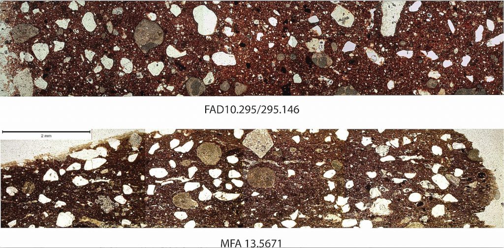
A recent petrographic study of ceramic jars from Giza imported into Egypt during the 4th Dynasty of the Pyramid Age (c. 2613–2494 BCE) identified the original production zone as the Lebanese coast generally between Beirut and Tripoli, including the region of Byblos. The jars and their contents were imported to Egypt by maritime trade expeditions conducted at the behest of the Egyptian state. This study analyses a selection of these ceramic samples using ICP-AES and -MS for comparison with published data from the region of Byblos. The results not only confirmed the underlying petrography, but together with new evidence from Lebanon suggests the vessels likely belonged to specialised workshop production in the Byblos environs and were made specifically for export to Egypt. The finding sheds new light on the relationship between the Egyptian state and the polity of Byblos in the Early Bronze Age, indicating the presence of standardised local production and commodity procurement mechanisms tailored to the needs of a large trade entity. This relationship in turn delivered significant prestige and status to local elites in an environment of competitive local peer-polity interactions.

The Annual Meeting of the American Society of Overseas Research (ASOR)

The in-person Annual Meeting of the American Society of Overseas Research (ASOR) was held in Chicago on November 17-20, 2021. The CRANE project’s scholars participated in several sessions/workshops.

Timothy P. Harrison and Miller C. Prosser served as chairs for the workshop entitled Grand Challenges for Digital Research in Archaeology and Philology. While last year this workshop focused on the challenge of data digitization, this year it looked at the challenge of integrating data sets. Within this workshop Stephen Batiuk, Sandra Schloen, and Stanley Klassen gave a presentation entitled “There and Back Again: Tayinat’s Tale”.

The CRANE project was also well represented in the workshop on Environmental Archaeology of the Ancient Near East. Within this workshop Lynn Welton, Simone Riehl, Dan Lawrence, and Hervé Reculeau presented a paper entitled “Fertile Ground: Methods for Estimating Ancient Agricultural Productivity”.

Further information about other sessions, abstract booklet, photos, and the event recap can be found on the ASOR website.

The Karkemish 3D Visualization Project

From Nicolò Marchetti 

The Karkemish 3D Visualization Project website is online, allowing for a virtual exploration of ancient architecture through different levels of information.

Karkemish 3D Homepage (Property of The Karkemish 3D Visualization Project).

The project is based on the principle that the digital revolution is
about limitless sharing, the defining feature of Open Science.
Scientific accuracy is the necessary characteristic of this project:
it is both a tool for scientific study as well as a means of public
dissemination for complex historical and cultural contents. Since
2011, the Turco-Italian Archaeological Expedition at Karkemish by the
Universities of Bologna, Gaziantep and Istanbul acquires and produces
3D models for documentation and study purposes of archaeological
materials and contexts. The Karkemish 3D Visualization Project aims at
virtually recreating in a 3D environment (based on Unreal Engine 4
incorporating the photogrammetric models) both monuments and
materials. By launching the application (which exploits the computing
power of your own device in order not to create delays on the server)
you will be able to walk around the Lower Palace Area model, turning
on and off the decorated orthostat models with the possibility to
inspect them for more information and visual details about that
particular artifact, adding also the reconstructions of the building
in which they were set; or just to explore in a dedicated environment
each of the decorated slabs filed in our database (which will be
expanded in the near future).

The Karkemish 3D Visualization Project is directed by Nicolò Marchetti
of the Alma Mater Studiorum-University of Bologna. The basis of the 3D
model is the photogrammetric survey – carried out by Giampaolo Luglio
between 2012 and 2016 – of the renewed excavations at the site and of
the sculpted Iron Age orthostats kept in the Anatolian Civilizations
Museum, Ankara. Jacopo Monastero created the integrated 3D model
adding also his interpretations of the elevations and the tables with
the data concerning the orthostats; he also created the web visualizer
through libraries developed in Unreal Engine. To navigate the model
use the following commands.

To turn your visual, move mouse holding left or right button. Move
with Up, Down, Left, Right arrows and with W, S, A, D keys; jump with
“space”. Press the “I” key while the orthostat is in the center of the
screen (red cross) to access its database entry (and “I” again to
exit). Press “E” to enter the main menu.

We gratefully acknowledge the CRANE 2.0 project for having provided
the server on which our 3D model is running and support for Jacopo
Monastero’s research on Unreal Engine applications. The Directorate
General for Cultural Heritage and Museums, Ankara
is gratefully
acknowledged as well for its unfailing support both towards our field
and museum work.

The website has been conceived by Nicolò Marchetti as Scientific
Editor, with Jacopo Monastero as Web Engineer and 3D Architect,
Silvano Bertossa as Webmaster and Valentina Orrù as Web designer.

Congratulations Lynn Welton!

We are pleased to announce the recent appointment of Dr. Lynn Welton (effective September 1, 2021) as an Assistant Professor of Near Eastern Archaeology (CLTA) in the Department of Near and Middle Eastern Civilizations (University of Toronto).

Dr. Welton received her PhD in Near Eastern Archaeology from the University of Toronto, and has twenty years of field experience, having worked in Turkey, Jordan, Iraq, Iran and Ethiopia. Geographically, she focuses primarily on the Levant and Anatolia, especially on the Late Chalcolithic, Early Bronze Age and Early Iron Age, having published extensively on materials from the Amuq Plain in southern Turkey as part of her long-term involvement with the Tayinat Archaeological Project.

Lynn’s recent work as part of the CRANE Project reconstructs human-environment interaction using a combination of climate modelling and agent-based modelling to evaluate agricultural strategies and decision-making as responses to climate change, in addition to ongoing research into agricultural productivity and land use in the ancient Near East. During her recently completed Marie Curie fellowship at Durham University, she used isotopic analysis of animal skeletal remains to investigate the role of pastoral mobility in the rise of complex societies in the Jordan Valley and western Syria during the 5th-3rd millennia BCE. In the Department of Near and Middle Eastern Civilizations (NMC), she will teach courses in Near Eastern archaeology.

Recent Publications

We would like to bring to your attention a selection of recent publications by our CRANE partners from the Carleton University, Durham University, and from our core members at the University of Toronto.

Carter, B., Blackadar, J., & Conner, W. (2021). When Computers Dream of Charcoal: Using Deep Learning, Open Tools, and Open Data to Identify Relict Charcoal Hearths in and around State Game Lands in Pennsylvania. Advances in Archaeological Practice, 1-15.

Abstract

This research employs machine learning (Mask Region-Based Convolutional Neural Networks [Mask R-CNN]) and cluster analysis (Density-based spatial clustering of applications with noise [DBSCAN]) to identify more than 20,000 relict charcoal hearths (RCHs) organized in large “fields” within and around State Game Lands (SGLs) in Pennsylvania. This research has two important threads that we hope will advance the archaeological study of landscapes. The first is the significant historical impact of charcoal production, a poorly understood industry of the late eighteenth to early twentieth century, on the historic and present landscape of the United States. Although this research focuses on charcoal production in Pennsylvania, it has broad application for both identifying and contextualizing historical charcoal production throughout the world and for better understanding modern charcoal production. The second thread is the use of open data, open source, and open access tools to conduct this analysis, as well as the open publication of the resultant data. Not only does this research demonstrate the significance of open access tools and data but the open publication of our code as well as our data allow others to replicate our work, to tweak our code and protocols for their own work, and reuse our results.

Figure 4: Slope analysis of a portion of SGL 33 with manually recognized relict charcoal hearths (RCHs) in white numbered squares and Mask R-CNN–identified RCHs in light blue squares. RCHs with both blue and white were recognized by both methods. The number above the square is the confidence score (image by Benjamin Carter).

______________________________________________________________________________

Graham, S., and Simons, J., 2021, Listening to Dura Europos: An Experiment in Archaeological Image Sonification. Internet Archaeology 56.

Excerpt from the Introduction

Jennifer Baird writes, of the Yale University–French Academy Expedition to Dura Europos in 1928-1937 and the way the expedition composed photographs for record keeping and publication, ‘What might an archaeology of Dura have looked like if objects had been photographed as assemblages from single contexts rather than in typological or material-based groups?’ (2011, 442).

We ask instead, what might the archaeology of Dura Europos sound like?

What can we hear, if we extend our senses through digital prostheses to extend our ability to sense the world? In this article we present an experiment in sonifying the archaeological imagery analysed by Baird (2011) as a way of enhancing our engagement with these archival photographs.

______________________________________________________________________________

Morrison, K., E. Hammer, O. Boles, M. Madella, N. Whitehouse, M.-J. Gaillard, J. Bates, M. Vander Linden, S. Merlo, A. Yao, L. Popova, A.C., F. Antolin, A. Bauer, S. Biagetti, R. Bishop, P. Buckland, P. Cruz, D. Dreslerova, G. Dusseldorp, E. Ellis, D. Filipovic, T. Foster, M. Hannaford, S. Harrison, M. Hazarika, H. Herold, J. Hilpert, J. Kaplan, A. Kay, K.K. Goldewijk, J. Kolar, E. Kyazike, J. Laabs, C. Lancelotti, P. Lane, D. Lawrence, K. Lewis, U. Lombardo, G. Lucarini, M. Arroyo-Kalin, R. Marchant, M. McClatchie, M. McLeester, S. Mooney, M. Moskal-del Hoyo, V. Navarrete, E. Ndiema, M. Nowak, W. Out, C. Petrie, L. Phelps, Z. Pinke, T. Russell, A. Sluyter, A. Styring, S. Veerasamy, L. Welton, and M. Zanon. (2021) “Mapping past human land use using archaeological data: a new classification for global land use synthesis and data harmonization”. PLoS ONE 16(4): e0246662.

Abstract

In the 12,000 years preceding the Industrial Revolution, human activities led to significant changes in land cover, plant and animal distributions, surface hydrology, and biochemical cycles. Earth system models suggest that this anthropogenic land cover change influenced regional and global climate. However, the representation of past land use in earth system models is currently oversimplified. As a result, there are large uncertainties in the current understanding of the past and current state of the earth system. In order to improve representation of the variety and scale of impacts that past land use had on the earth system, a global effort is underway to aggregate and synthesize archaeological and historical evidence of land use systems. Here we present a simple, hierarchical classification of land use systems designed to be used with archaeological and historical data at a global scale and a schema of codes that identify land use practices common to a range of systems, both implemented in a geospatial database. The classification scheme and database resulted from an extensive process of consultation with researchers worldwide. Our scheme is designed to deliver consistent, empirically robust data for the improvement of land use models, while simultaneously allowing for a comparative, detailed mapping of land use relevant to the needs of historical scholars. To illustrate the benefits of the classification scheme and methods for mapping historical land use, we apply it to Mesopotamia and Arabia at 6 kya (c. 4000 BCE). The scheme will be used to describe land use by the Past Global Changes (PAGES) LandCover6k working group, an international project comprised of archaeologists, historians, geographers, paleoecologists, and modelers. Beyond this, the scheme has a wide utility for creating a common language between research and policy communities, linking archaeologists with climate modelers, biodiversity conservation workers and initiatives.

______________________________________________________________________________

Gaastra, J., L. Welton, M. de Gruchy, and D. Lawrence (2021). “Landscapes, Climate and Choice: Examining Patterns in Animal Provisioning Across the Near East, c. 13,000-0 BCE”. Quaternary International 595: 54-87.

Abstract

Understanding the organisation of food production is vital for understanding ancient societies. Multiple factors may influence decision making, including the local environmental capacity of a given area and individual and cultural preferences. This study compares zooarchaeological data from sites across the length and breadth of the Holocene Near East with modelled patterns of land use. The goal is to determine how far variation in the capacities of local landscapes impacted the choices made in animal production. Our approach allows us to investigate trends through time as well as between different regions of the Near East. The spatial and temporal scales employed also mean we can investigate the relationship between food production and climate trends. We find substantial patterning in the choices made in animal production, reflecting complex and regionally diverse production approaches. We demonstrate a prioritisation of individual and societal preferences to produce specific animals which is rarely impacted by either short or long term changes in aridity. We also find that the emergence of urban sites has a major impact on provisioning structures, and argue that the resulting organisational forms may have resulted in urban sustainability at the expense or rural sites.

  • « Previous Page
  • 1
  • 2
  • 3
  • 4
  • 5
  • …
  • 9
  • Next Page »