CRANE

Inside CRANE

Powered by Genesis

A new home for the OCHRE Data Service at the University of Chicago

Announcement by Sandra Schloen (Manager, OCHRE Data Service):

As University of Chicago reopens for the Autumn quarter, I want to update you on the reopening of the OCHRE Data Service in a new home in the center of campus. As we celebrate our tenth anniversary and approach the landmark of 10 million database items managed by the OCHRE platform, we are excited to be expanding and broadening our reach. Effective July 1, 2021, the OCHRE Data Service has moved from the Oriental Institute to the Division of the Humanities, affiliating with the program in Digital Studies of Language, Culture, and History. I am joining the program as the Technology Director for Digital Studies, reconnecting with Miller Prosser who became the Associate Director of Digital Studies last September.

Going forward, we will be better positioned to provide database services, consultation, and training for students and faculty in all fields of the humanities, ancient, medieval, or modern, including ongoing support for our research projects at the Oriental Institute. We are also pleased to be able to provide technology-related support to the Digital Studies program, working with students eager to develop technical skills to enhance their studies in the Humanities.
Past Populations’ Survival and Agent-Based Modeling

Agent-based modeling (ABM), a type of computer simulation that investigates the behaviour of individual people, groups, or objects, might seem difficult to apply to Northern Mesopotamia during the Bronze Age, where many details of daily life remain unknown to us. But CRANE is aiming to do just that with its agent-based modeling project, which uses these models to help understand agricultural decision-making in dry-farming areas of the ancient Near East. CRANE’s work initially grew out of a model developed for the MASS (Modeling Ancient Settlement Systems) Project by the late John Christiansen of the Argonne National Laboratory in Chicago. The current iteration of the model is the work of Dr. Lynn Welton, an Assistant Professor in the Department of Near & Middle Eastern Civilizations at the University of Toronto and a core member of CRANE.

The “agents” in this model are hypothetical people, organized into households; they are created based on the best information available about demographics, fertility and mortality in the period. The model then puts them through a series of actions that simulates the process of planting and growing crops and consuming food, all while introducing the kinds of obstacles that they would have encountered in ancient times. As in the real world, they are “constrained in their ability to complete the tasks by the availability of labour in their household,” Welton explains, “and if a household does not have enough food to support its members, individuals die from lack of nutrition.” By running different simulations based on different variables, and comparing the results to available archaeological data, Welton says that ABM “allows us to outline a range of possibilities and virtually explore possible mechanisms that could have led to the patterns we see archaeologically.”

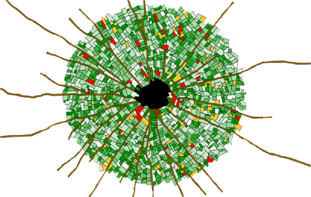
Output from CRANE’s agent-based model showing the locations of cultivated fields after the model has been run for 250 years.

These models are still in the early stages of development, and are constantly being updated to create more accurate simulations; for example, the current model uses only one crop species, but Welton is working “to allow households to choose between different crops that have different patterns of productivity.” Other CRANE projects will help to inform this one as well. The results of CRANE’s climate modeling project, directed by Richard Peltier, will be used to bring nuance to the ABM project by adding more detailed, accurate climate data to the models. It is also increasingly informed by new research on ancient agriculture; Welton points in particular to Hervé Reculeau, her collaborator at the Oriental Institute of the University of Chicago, whose input is improving the model by creating more accurate knowledge about sowing, plowing, harvesting, and other agricultural processes based on data from ancient textual sources.

Welton adds that the model has already yielded some ideas about what situations populations could and couldn’t survive: for example, it suggests that while households could withstand short-term losses, “crop failures of 3+ consecutive years, which outlast the typical storage life of household grain supplies, result in dramatic population collapse in the model; introducing various coping strategies may help to mitigate this collapse.

Output from CRANE’s agent-based model showing the response of the population to a two-year crop failure.

”As the models and simulations become more sophisticated and wide-ranging, they’ll be able to test more theories about how people lived. “What we’re doing is trying to systematically test possible scenarios, in order to identify feedbacks between different variables,” Welton explains. “We don’t necessarily always have to know all the details about the past to develop a model that is useful to us.”

Written by Jaime Weinman.

Canadian archeologist devotes life to history of southern Turkey

Reposted from Daily Sabah, August 8, 2021.

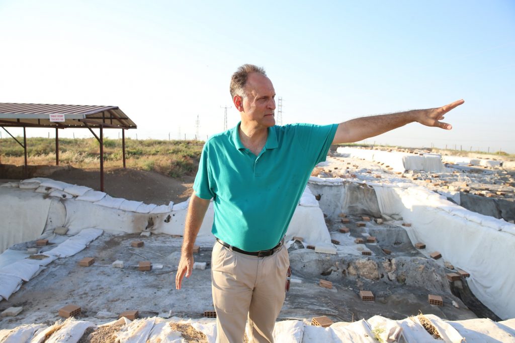
Professor Timothy Harrison in Tell Tayinat, Hatay, southern Turkey, August 8, 2021. (AA Photo)

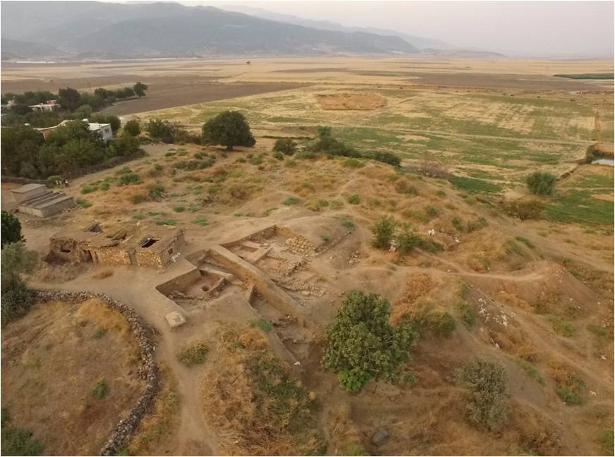
Dedicating his life to tracing the history of humanity, Canadian archeologist Timothy Harrison has been conducting excavations at the archeological site of Tell Tayinat in the Reyhanlı district of Turkey’s southernmost Hatay province since 2004. A tell refers specifically to an ancient mound in the Middle East composed of the remains of successive settlements.

The archeologist from Toronto University, who obtained his doctorate from the University of Chicago, has unearthed numerous artifacts over the 17 years he has been working in these Anatolian lands. He has spent almost four decades conducting archaeological fields studies in countries of the Levant, which in addition to Turkey would also include Syria, Israel, Lebanon and Jordan.

Professor Timothy Harrison poses with archaeological finds that they unearthed in Tell Tayinat, Hatay, southern Turkey, August 8, 2021. (AA Photo)

Harrison visits Turkey each seasonal excavation and conducts meticulous work with his team to unearth findings that can shed light on history.

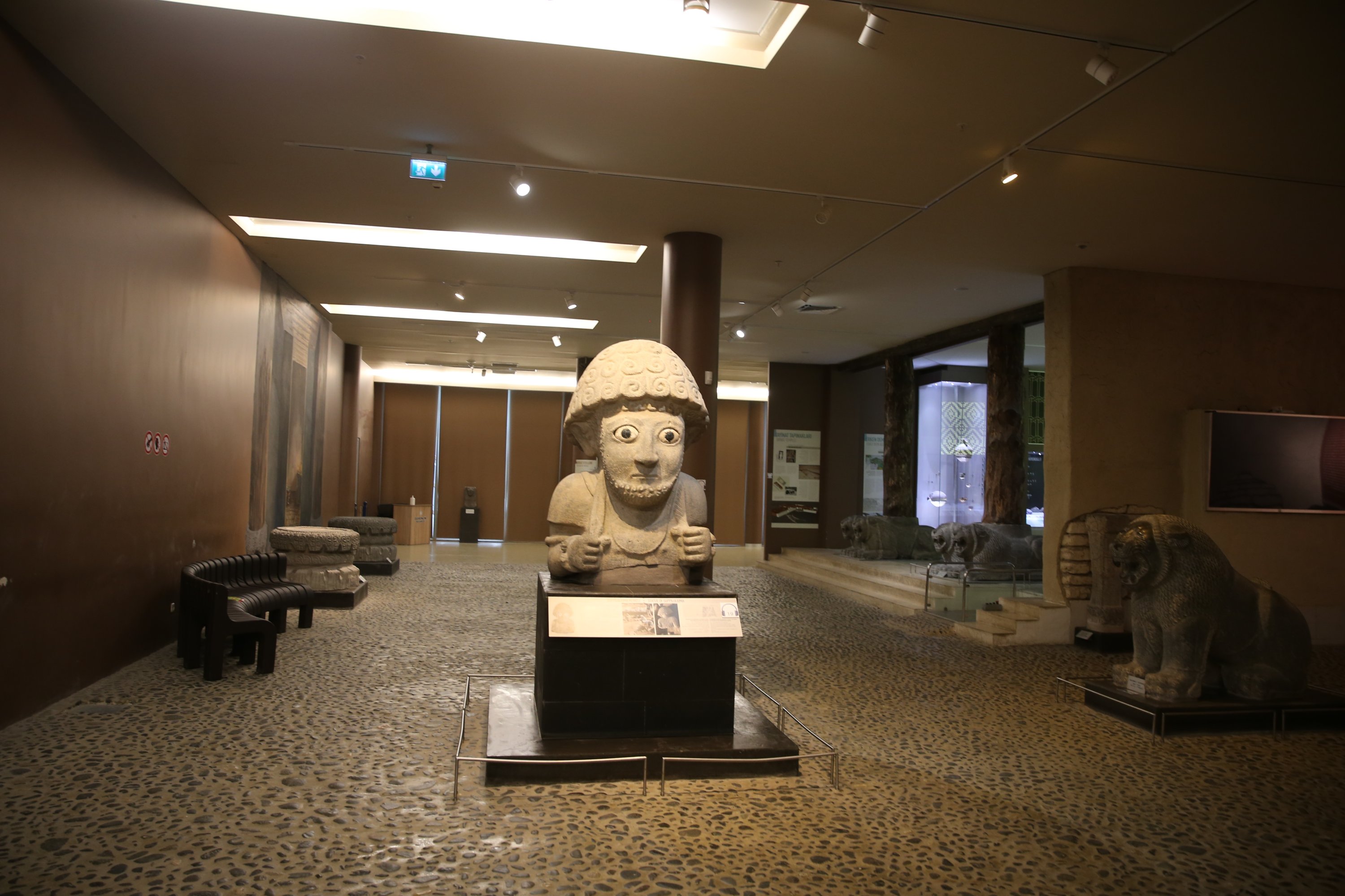
Among the artifacts that Harrison and his team have unearthed at Tell Tayinat are two statues that are 1.5 meters (4.9 feet) in length belonging to King Suppiluliuma and his wife from the Late Hittite Empire period of the 9th century B.C.

The professor told Anadolu Agency (AA) that he took part in excavations around the world during his 35-year career and said he takes great pride in presiding over excavations in Tell Tayinat.

Noting that his team has recovered numerous artifacts ranging from treaty cuneiform tablets to statues, he said archeologists and students from Turkey, the U.S., U.K., Germany, Belgium, France and the Middle East also participate in excavations.

“As a result of our meticulous works, we have unearthed temples, statues, palaces among other innumerable artifacts,” he said. “If ceramics, botanical findings, organic residuals are counted too, the number of findings amount to thousands.”

Some of these finds are on display at the Hatay Archaeological Museum, while others are kept in the excavation stores, according to Harrison.

The statue belonging to King Suppiluliuma in the Hatay Archaeological Museum, southern Turkey, August 8, 2021. (AA Photo)

The archaeologist said he wants to participate in excavations in Tell Tayinat as long as he lives. “Only little of the mysteries and artifacts on this tell have been unearthed yet. The excavations here will continue for many years.”

He also said King Suppiluliuma’s palace is believed to have been under a factory in the area, and the team wants to uncover the palace during upcoming excavations.

Old Information, New Context: The Antioch Digital Companion Project

The Antioch Project, comprising a series of excavations at this great imperial city in southeastern Turkey in the 1930s, was among “the most ambitious, and altogether problematic, excavations ever undertaken,” says Andrea De Giorgi, an Associate Professor in the Department of Classics at Florida State University. Working in the city of Antakya (or Antioch as English speakers called it at the time), the excavators recorded a vast number of images, architectural plans and other data, which CRANE’s partner, the OCHRE Data Service, had already made available through its institutional partner, the Oriental Institute of the University of Chicago. But De Giorgi says the data was never organized with any kind of meaningful context: “They’re essentially JPEGs, just very static images that don’t really communicate in terms of where they were found and why they were situated there.” This led De Giorgi, working with CRANE’s Stephen Batiuk and Julia Gearhart at Princeton University, to initiate the Antioch Digital Companion Project, which aims to help people navigate all this data.

The idea for the Antioch Digital Companion Project came about after De Giorgi co-authored the book Antioch: A History with A. Asa Eger, an Associate Professor of the Islamic world at the University of North Carolina at Greensboro, with maps created by Stephen Batiuk. De Giorgi says they were impressed by the way CRANE’s system could be used to “document the modifications of the city from the Hellenistic foundation to the Ottoman era,” and he, Eger and Batiuk came up with the idea to do the same thing on a larger scale, allowing the user to see where every item stands in relation not only to the topography of the area, but the topography of the excavations.

GIS map of ancient Antioch, courtesy of OCHRE.

With the help of CRANE, De Giorgi continues, the Digital Companion Project was able to take a bare piece of data like an architectural plan, and present it “basically re-contextualized. It’s not just floating, it’s not just an image of a building; we have fully appropriated and reinserted it into an image of the territory as it was after the excavation.” This is possible because of CRANE’s system; “thanks to GIS processing, and thanks to aerial photographs and thanks to remote sensing,” De Giorgi says, it’s possible to show “the correlation between the ancient landscape and the way the terrain looks today.”

Now that the Digital Companion is almost finished, De Giorgi says they will move on to the nearby Mediterranean coast, where the original Antioch Project ventured for some unfinished expeditions, and use these tools to create a similar resource. De Giorgi is enthusiastic about CRANE’s ability to help them take raw, unprocessed information and give it an intelligible shape: “We would like to go back to these fragmented narratives,” he explains, “and we would like to try to piece them together.”

Written by Jaime Weinman.

EVENT: “Plant ways in Middle Bronze Age Anatolia – An archaeobotanical investigation of seeds and fruit remains at Zincirli Höyük, south-central Turkey”

Lecture by Doğa Karakaya

Reposted from Bioarchäologische Gesellschaft website.

June 8, 2021, 18:30 – 20:00 PM (Central European Summer Time); 12:30 PM EST (Toronto, Canada)

Middle Bronze Age is marked by the increasing internationalism in the Near East through the seizure of political control by Semitic Amorite kings. Various texts mention these nomadic tribes as threatening the political order of the Ur III dynasty in southern Mesopotamia at the end of 3rd millennium BC. With the beginning of Middle Bronze Age, however, the Amorite kingdoms were successfully established themselves in much of the Near East. Moreover, such international contacts are also apparent from the Mari and Kültepe texts in which rulers from Mesopotamia, Levant and Minoan Crete were exchanging gifts and commodities among each other. While some of these texts mention long-distance trade of value-added products like olive oil and wine; they are not particularly descriptive of the production and processing stages of these products. In this paper, we present the preliminary results of the macro-botanical (seeds and fruits) remains from a Middle Bronze Age layer (ca. 1650 BC) at Zincirli Höyük (Turkey). The study area was destroyed after a single conflagration event with several food processing installations and restorable vessels in-situ. In addition, the archaeological contexts were minimally disturbed by later sedimentary and anthropogenic activities. This preliminary contribution aims to present the plant data on storage and processing of crops in the studied context.

Doğa Karakaya is an archaeobotanist at the University of Tübingen and visiting researcher at the Austrian Archaeological Institute (ÖAI) of the Austrian Academy of Sciences (ÖAW).

Free event.

Zoom link: https://oeaw-ac-at.zoom.us/j/96236520834?pwd=S3B5K2VlM2dyZ3ZwdGlMT3h0T0JKZz09 (Password: PWC69M).

  • « Previous Page
  • 1
  • 2
  • 3
  • 4
  • 5
  • 6
  • …
  • 9
  • Next Page »